16. A confined aquifer under pressure also known as __________
(A) Phreatic aquifer
(B) Unconfined aquifer
(C) Artesian aquifer
(D) Perched aquifer
(C) Artesian aquifer
Explanation: A confined aquifer under pressure is also known as an artesian aquifer. When tapped by a well, water in an artesian aquifer can rise above the level of the aquifer.
17. Which of the following processes can lead to groundwater depletion?
(A) Increased infiltration
(B) Enhanced recharge areas
(C) Over-pumping for agricultural and industrial use
(D) Decreased surface runoff
(C) Over-pumping for agricultural and industrial use
Explanation: Groundwater depletion occurs when water is pumped out of aquifers at a faster rate than it can be naturally recharged, often due to excessive agricultural and industrial use.
18. What is the term for the boundary between the zone of saturation and the zone of aeration?
(A) Aquitard
(B) Water table
(C) Capillary fringe
(D) Permeable layer
(B) Water table
Explanation: The water table is the boundary between the zone of saturation, where all pores are filled with water, and the zone of aeration, where pores contain both air and water.
19. What is the role of a recharge well in geohydrology?
(A) To extract groundwater for consumption
(B) To introduce water into an aquifer for replenishment
(C) To measure groundwater levels
(D) To detect subsurface contaminants
(B) To introduce water into an aquifer for replenishment
Explanation: A recharge well is used to introduce water into an aquifer to help replenish groundwater supplies and maintain the water table.
20. Which of the following best describes the term “hydraulic conductivity”?
(A) The measure of the total volume of water in an aquifer
(B) The ability of a material to transmit water
(C) The speed at which groundwater flows
(D) The amount of water that can be extracted from an aquifer
(B) The ability of a material to transmit water
Explanation: Hydraulic conductivity is a measure of a material’s ability to transmit water, which depends on the permeability and the viscosity of the fluid flowing through it.
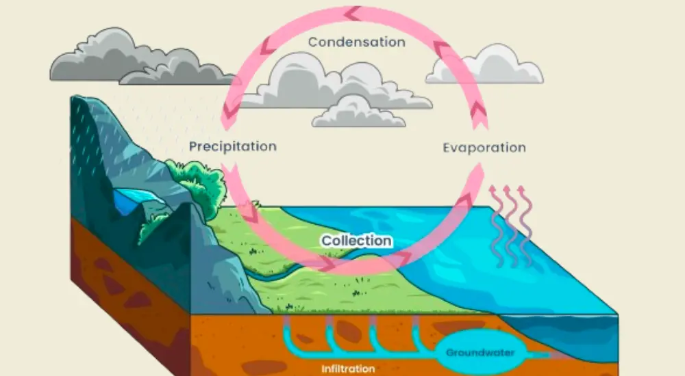
21. What is the term for the downward movement of water from the land surface into the soil or rock?
(A) Runoff
(B) Percolation
(C) Infiltration
(D) Evapotranspiration
(C) Infiltration
Explanation: Infiltration is the process by which water on the land surface enters the soil or rock, replenishing groundwater supplies.
22. Which type of aquifer is recharged directly from the surface and is not confined by impermeable layers?
(A) Confined aquifer
(B) Perched aquifer
(C) Unconfined aquifer
(D) Artesian aquifer
(C) Unconfined aquifer
Explanation: An unconfined aquifer is directly recharged from the surface and is not confined by impermeable layers, allowing water to move freely in and out.
23. What is a major consequence of excessive groundwater pumping in coastal areas?
(A) Increased surface runoff
(B) Ground subsidence
(C) Saltwater intrusion
(D) Formation of sinkholes
(C) Saltwater intrusion
Explanation: Excessive groundwater pumping in coastal areas can lead to saltwater intrusion, where seawater infiltrates and contaminates freshwater aquifers.
24. What is the term for a body of rock that impedes the flow of groundwater?
(A) Aquifer
(B) Aquitard
(C) Permeable layer
(D) Recharge zone
(B) Aquitard
Explanation: An aquitard is a body of rock or sediment that impedes the flow of groundwater due to its low permeability.
25. How is the hydraulic gradient calculated in geohydrology?
(A) By dividing the difference in hydraulic head by the distance between two points
(B) By measuring the volume of water flowing through an aquifer
(C) By determining the water table depth
(D) By calculating the rate of evaporation
(A) By dividing the difference in hydraulic head by the distance between two points
Explanation: The hydraulic gradient is calculated by dividing the difference in hydraulic head (water level) between two points by the distance between those points, indicating the direction and steepness of groundwater flow.
26. What is the main source of groundwater contamination from agricultural activities?
(A) Saltwater intrusion
(B) Pesticides and fertilizers
(C) Industrial discharge
(D) Leaking septic systems
(B) Pesticides and fertilizers
Explanation: Pesticides and fertilizers used in agriculture can leach into the soil and contaminate groundwater, posing risks to water quality and health.
27. What is the specific yield of an aquifer?
(A) The total volume of water in the aquifer
(B) The volume of water that can be extracted by pumping
(C) The rate at which water enters the aquifer
(D) The measure of the aquifer’s porosity
(B) The volume of water that can be extracted by pumping
Explanation: Specific yield is the volume of water that can be drained from an aquifer by gravity and extracted by pumping, expressed as a percentage of the total volume of the aquifer.
28. Which geological formation is least likely to form a productive aquifer?
(A) Sandstone
(B) Limestone
(C) Shale
(D) Gravel
(C) Shale
Explanation: Shale is least likely to form a productive aquifer because it has very low permeability, making it difficult for water to flow through.
29. What is the main purpose of a groundwater monitoring well in hydrogeology?
(A) To extract groundwater for use
(B) To recharge an aquifer with surface water
(C) To measure and monitor groundwater levels and quality
(D) To detect seismic activity
(C) To measure and monitor groundwater levels and quality
Explanation: A groundwater monitoring well is installed to measure and monitor groundwater levels, pressure, and quality over time, helping manage and protect groundwater resources.


